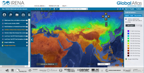
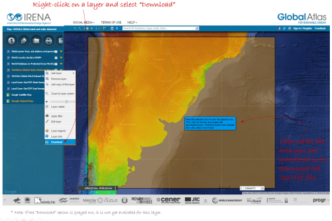
For the first time, privately-produced renewable energy resource data is available for download to all for free. This past May, IRENA’s Global Atlas for Renewable Energy unveiled a new feature that allows users to download renewable resource data from selected datasets for offline analysis. Up to now, only data from selected publicly-funded sources was available. This has changed now that Vaisala, a global leader in environmental and industrial measurement, has made its average annual data on solar irradiation and wind speeds available for download through the Global Atlas. This capability gives developers, policy makers, and researchers access to globally consistent resource data that can be used in setting policy and performing initial project planning and prospecting.

Nicolas Fichaux, Senior Programme Officer at IRENA, is proud of the progress the Global Atlas has made since it was launched in 2013. “Our common goal is to accelerate the growth of renewables worldwide. By pushing the boundaries of publicly available resource data, IRENA and Vaisala are helping the sector to move faster by lowering the complexity of entry into new renewable energy markets. The private sector recognizes the challenge, and this contribution from Vaisala demonstrates their continued support for IRENA’s work.”
Pascal Storck, Global Manager of Energy Services at Vaisala, added: “Facilitating access to reliable resource data is an essential first step when it comes to supporting global renewable energy expansion. It’s our goal and responsibility to minimize investment risk for the industry throughout the lifecycle of projects – from the early-stage prospecting efforts this data enables to the more detailed financial forecasts and real-time operational support we provide to clients. Working with IRENA as part of the Global Atlas initiative gives us the opportunity to maximize the reach of our global wind and solar datasets to the benefit of the international renewable energy development community and its ambitions in promising new markets.”
Data can be downloaded from the Vaisala map in the Global Atlas in GeoTIFF format in portions of 4 MB. Vaisala’s global wind dataset provides average annual wind speeds at a height of 80 meters and a resolution of 5 km, based on ten years of hourly data from advanced simulations and validated against ground measurements. The global solar data set provides average annual global horizontal irradiation (GHI) at 3 km resolution. The data is based on over ten years of hourly data derived from satellite imagery and validated against ground measurements.

For more information on how to download data with the Global Atlas, watch our short tutorial on the new features in Version 2.1, or watch our recent webinar on Solar Resource Assessment with the IRENA Global Atlas for Renewable Energy, featuring a presentation from Gwen Bender, Product Manager for Energy Services at Vaisala.


